Integrated Stormwater Retention System
By Brock Dolman and Kate Lundquist
Photographs by Brock Dolman and Jim Coleman
Table of Contents
Resources
Acknowledgements
We would like to thank the Dean Witter Foundation and the 11th Hour Foundation for their generous support of our work.
OAEC’s WATER Institute was established to offer positive responses to the crisis of increasingly degraded water quality and diminishing water quantity. We promote a holistic and multidisciplinary understanding of healthy watersheds through our four interrelated program areas — Watershed Advocacy, Training, Education, and Research.
The Occidental Arts and Ecology Center (OAEC) is a nonprofit education and organizing center and organic farm in Northern California’s Sonoma County. Since 1994, OAEC has explored, implemented, and provided education for innovative and practical approaches to the pressing environmental and economic challenges of our day.
INTRODUCTION
Stormwater is water flowing on land surfaces during or within 24 hours of a precipitation event that is not infiltrated into the soil. Historically it has been viewed as a problem primarily of urban areas to be solved by the outmoded engineering practice of “pave it and pipe it.” This method fails to properly manage stormwater in the uplands, leading to disastrous consequences: large, powerful volumes of water moving too fast, resulting in severe erosion and flooding in low-lying areas. This excessive runoff requires expensive engineered systems that simply move the problem downstream until the runoff enters a stream and ultimately the ocean, leaving the ecosystem to absorb the excess volume and pollution.
Instead of a problem, water can more accurately be viewed as an enormously valuable resource to be sequestered and re-used whenever possible. Slowing, spreading and sinking stormwater generated by impervious surfaces as high as possible in the uplands of any watershed will increase infiltration and ensure that any water discharged will be clean and moving slowly enough to avoid erosion and sedimentation problems.
In many California coastal communities, reliable access to fresh water is limited and water quality and quantity are growing concerns. Current trends toward longer droughts and more severe storms render traditional methods of stormwater management even less effective. In response, development of a robust, scalable, de- centralized stormwater management strategy is critical for addressing watershed health and water security.
Implementation of effective stormwater management measures results in many benefits which address both human needs and total watershed health, including:
- Increasing upland water infiltration and retention capacity improves water security by recharging groundwater aquifers and improving the productivity of wells.
- Slowing down stormwater runoff decreases topsoil loss, erosion, flooding and stream flow variance by reducing the volume and rate of peak flow events.
- Removing pollutants in runoff improves water quality in streams and aquifers.
To demonstrate the effectiveness of innovative stormwater management practices, OAEC designed and installed an Integrated Stormwater Retention System in 2011. This unique system integrates various techniques, including: head cut mitigation, infiltration swales, sediment basins, multifunctional hedgerows, and native bunch grasses sown by drilling along keylines.
The system was installed below parking lots, a large greenhouse complex and a former horse pasture. Previously, these land uses generated significant increases in stormwater runoff volumes and velocities, resulting in increased erosion, gully head cutting and direct sediment delivery to our natural waterways. As a demonstration center for sustainability practices, OAEC has a responsibility to provide an effective example of mitigating these stormwater impacts. By improving water quality and infiltration, this new system demonstrates a rural residential approach to integrated stormwater management that moves away from drainage-based solutions and towards retainage-based solutions that also promote increased biodiversity.
This project is our most ambitious and integrated system to date and has been part of our land management visioning process for many years. Located in a highly prominent area of our land, the system is visible to thousands of visitors and students that annually visit OAEC’s site. While most low-impact development (LID) techniques have been well demonstrated as effective tools in the suburban and urban sectors, this Integrated Stormwater Retention System serves to address the community’s need for a complementary rural demonstration.
SYSTEM DESCRIPTION
Since 2004, OAEC’s WATER Institute has been implementing an on-site Conservation Hydrology Adaptive Management Plan (CHAMP) that employs and demonstrates renewable energy technologies and best management and conservation practices for water, in addition to the energy associated with its use. These practical solutions include: graywater systems, micro-hydro generated electricity, roof water catchment systems, a rainwater harvesting pond that supplies 100% of our irrigation needs, a solar thermal hot water system, bio-filtration to improve water quality in a koi-pond, numerous swales and rain gardens, fish-friendly rural road improvements and a 10-kilowatt solar photovoltaic system (see page 17 for project reports).
In the spring of 2011, we consulted with Restoration Ecologist, Jim Coleman, M.S to design a new, enhancing element for our CHAMP – an Integrated Stormwater Retention System. With regard to physical function, the two primary design goals were to improve water quantity through increasing our well water production and improve surface water quality of our streams that drain into our salmonid bearing creek. The design needed to offset the run-off associated with the new greenhouse roofs, the existing road and the compacted soil of the former horse pasture, all of which were accelerating the rates of surface erosion and gully head cut migration that were contributing sediment to nearby creeks. Additionally, this rapid run-off prevented optimal infiltration of rainwater into our adjacent water supply well.
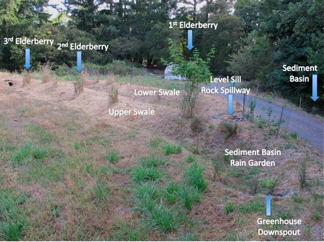
This system includes two different excavated sediment basins that double as wildlife habitat ‘raingardens’ and are associated with two long swale systems that have been planted with a multi-functional hedgerow. On the slopes above the swales, we utilized a keyline plow to improve infiltration and simultaneously sow keyline strips of native bunch grasses to improve erosion control, recharge groundwater and build soil. By design, the system elements are strategically located near the only water well on site, which serves as the property’s sole source of potable water. The design incorporated information from previous research on the relationship between stormwater infiltration and groundwater levels in our well. The research was conducted as follows.
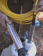
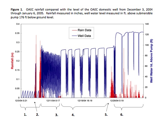
In 2004, the WATER Institute installed both a weather station with a rain gauge and a pressure transducer (see photo below left) with associated data logger into the well (see diagram below right). This equipment allows us to monitor rainfall and the change in ground water elevation on a daily basis.

Over a two-year period, we were able to determine how rainfall and human use affect changes in groundwater elevation as observed in the well (see Figure 1.)
2. First big rain event.
3. Ground water rises, pump works to fill tank.
4. Pump intermittently fills tanks as community use pattern emerge.
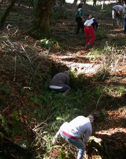
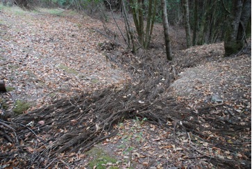
During the design process, we determined that immediate mitigation of existing erosion was a high priority and needed to be addressed first. In the spring of 2011, the WATER Institute enlisted 28 Permaculture Design Course students to cut invasive woody Scotch Broom (Cytisus scoparius) and overcrowded Douglas fir (Pseudotsuga menziesii) from surrounding grasslands and forests to mitigate the eroding gully. Removing the broom gives native grasses a chance to flourish, while the fir removal reduces the potential for catastrophic fires in the forest. These materials were installed in the eroded gully to trap soil and prevent further head cut migration and the associated erosion.
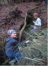
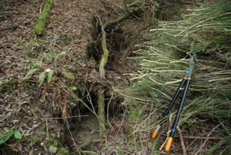
To make this kind of erosion control work, one must be certain the brush and woody material is firmly placed in the gully. This can be achieved by stabbing the butt ends into the soil and subsequent layers of branches, weaving brush together into a dense matrix, and stomping brush to compact it and ensure thorough contact between brush and the gully walls. It is most effective to place branches with the tips pointing uphill and the cut ends downhill to increase filtration surface area. It is important to fill all voids so water cannot concentrate in volume and undermine the structure. The end result should be a densely packed but porous matrix that disperses the flow of water while trapping soil and leaf litter particles.
It is best to use fresh green material so that the leaves from the drying branches can fall and fill in the voids. If you must use dry, leafless or large woody materials (logs), you must also include a weed-free source of carbon (such as straw) to infill the micro spaces.
Over time, this material composts and results in a fertile and water-holding sponge into which the adjacent tree roots grow. These roots further stabilize the gully, restore the slope to its original grade, and support a stable soil profile that is resistant to erosion. The removal of the gully elevates the surrounding shallow groundwater, making it available to adjacent plants and improving soil moisture conditions during drought.
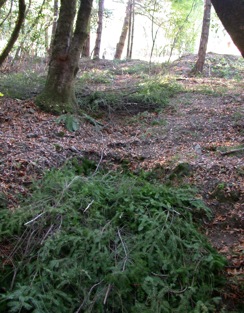
As with most restoration projects, these repairs need to be monitored and maintained. As the repair materials decompose, you may need to add new material over the years to bring the level up to grade until a stable level has been achieved.
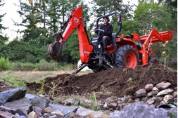
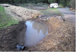
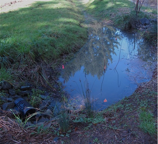
In summer 2011, the WATER Institute installed the next phase of the Integrated Stormwater Retention System, which was comprised of two swales and associated sediment basins. We placed sediment basins in two locations where sediment-laden water was most likely to first enter the structure. These basins are both accessible from the road so, if needed, they can be cleaned out with a backhoe in the future. The sediment basins are deeper than the swales and can hold a greater volume of water for a longer period while the sediment drops out of the water. In small storm events, these basins will tend to be the first and only place that fills with water. The area immediately surrounding these basins will get more water and allow planting of more water-loving vegetation around its perimeter, thus functioning like the raingardens found in urban areas.
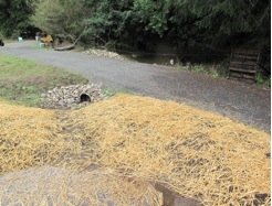
Once the upper sediment basins are full, they then begin to flow into the adjacent swales. By swale, we mean an infiltration trench dug on contour whose berm is built with the soil excavated to make the trench. Digging them on contour retains the greatest amount of water over the longest possible length of slope, resulting in optimal groundwater infiltration. The swales were laid out using an A-Frame leveling device to locate the contour line to be excavated on the slope. We mulched the berm with straw to prevent erosion and protect the soil. We have intentionally sized the capacity of the system in anticipation of less frequent but wetter storm events as predicted by climate change models. We have also designed and installed robust rock-lined spillways to safely manage large water overflows when the system has reached capacity.
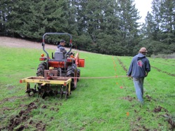
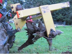
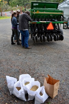
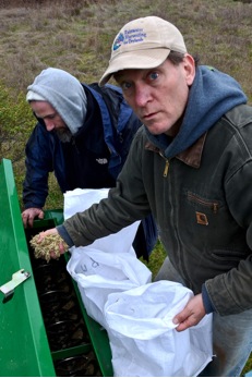
In Fall/Winter 2011, the all-native hedgerow was planted by students attending a Designing Edible Food Forests course taught by Eric Toensmeier at OAEC (see plant list on page 12). The former horse pasture was keyline plowed and sown with native grasses using the No-Till-Drill (see photos below). The seed drill was rented from our local Gold Ridge Resource Conservation District and is specifically designed to dispense native grass seeds. We chose to keyline plow off contour to evenly disperse the sheet flow from the pasture away from the road and towards the forest edge to optimize the recharge capacity and support the growth of native grasses. These long-lived and deep-rooted native grasses help to enhance water infiltration and sequester carbon.
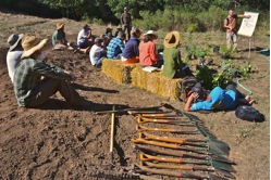
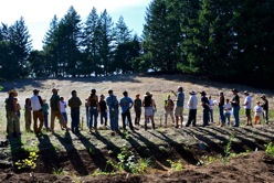
By planting both the hedgerow and the slope with California native plants and bunch grasses, we were able to highlight the use of native plants as part of wildland restoration concepts described in the seminal work Tending The Wild by Kat Anderson (2006). Many of the plants were selected for their cultural, medicinal and material value to the Coast Miwok and Southern Pomo tribes in the area. The plowing and seeding demonstration was open to the public. Land managers, contractors and landowners attended.
Now that the system has been in place for one season, we have made the following observations. As predicted with climate change, our 2011-2012 rain year was below average. Nearly 75% of the rain we received, however, arrived during four large rain events that delivered heavy precipitation in a short period of time. This water quickly saturated the soil and delivered significant runoff to our Integrated Stormwater Retention System. Since we had designed oversized swales for this type of large flow, we were able to harvest and retain almost all of the water in the system. All sediment produced was captured and retained within the sediment basins. The small percentage of water that overflowed the system was free of sediment. The two primary goals of the system were achieved – dramatically improved water quality and recharge quantity. The headcut has ceased to migrate and the erosion gully has stabilized. The water quality below the gully has dramatically improved, and we have ceased delivering sediment to nearby Calypso Creek
The plants are all flourishing. Of the three blue elderberries we planted in different locations along the top of the swale, the one closest to the first sediment basin (which receives water first from the greenhouse roof downspout) is three-five times larger than the ones planted 25-50 feet further from the basin, an area that receives standing water only during large storm events (see Figure 2.). This suggests that the first elder may be taking advantage of and benefiting from the extra water infiltrating its root zone. This supports the concept that planting perennial vegetation adjacent to seasonal water is effective and that plantings located in areas less frequently inundated may require supplemental irrigation.
In sum, as we witnessed problems with this section of the property, we also began noticing opportunities. Most notably, the excess runoff could help us solve the problem of the low production well nearby. We lead with the perspective of seeing constraints as opportunities. If form follows function and we envisioned multiple functions, then we needed to create a system comprised of multiple forms (road drainage, sediment basins, swales, stacked spillways, keyline plowing and native vegetation). Each of these elements provides different, specific roles within the system and support one another.
PLANT LIST
California Native Plants for OAEC WATER Institute’s Stormwater Swale/Hedge (aka “Swedge”)
UPPER CANOPY/SHRUB
Pacific Wax Myrtle Myrica californica
Grey Willow Salix exigua
Blue Elderberry Sambucus mexicana
Redbud Cercis occidentale
Hazelnut Corylus cornuta californica
Red Twig Dogwood Cornus stoloniera
Western Azalea Rhododendron occidentale
Spicebush Calycanthus occidentalis
Thimble berry Rubus parviflorus
Oso Berry Oemleria cerasiformis
Leatherwood Hoita macrostachya
Silk Tassel Garrya eliptica
Sugar Bush Rhus ovata
HERBACEOUS
Common Rush Juncus patens
Basket Sedge Carex barbare
Spike Rush Eleocharis sp.
Mugwort Artemisia douglasiana
Pacific Iris Iris douglasii
Cardinal Monkey Flower Mimulus cardinalis
Coltsfoot Petasites frigidus
Yampah Perideridia gairdneri
Coast Angelica Angelica hendersonii
Foothill Angelica Angelica tomentosa
Celery Weed Lomatium californicum
Common Camas Camassia quamash
LOW HERBACEOUS TO GROUNDCOVER
Meadow Barley Hordeum brachyantherum
Columbine Aquilegia formosa
CA Buttercup Ranunculus californicus
Bleeding Heart Dicentra formosa
Mariposa Lily Calochortus luteus
Yerba Buena Satureja douglasii
Woodland Strawberry Fragaria vesca
Yerba Mansa Anemopsis californica
Wild Ginger Asarum caudatum
Yarrow Achillea millefolium
VINES
Ninebark Physocarpus capitatus
Wild Grape Vitus californica
Pipestems Clematis lasiantha
GRASSES
California Brome Bromus carinatus
Blue Wildrye Elymus glaucus
Idaho Fescue Festuca idahoensis
Meadow Barley Hordeum brachyantherum
California Barley Hordeum californica ssp. californicum
Deer Grass Muhlenbergia rigens
Purple Needlegrass Nassella pulchra
Pine Bluegrass Poa secunda